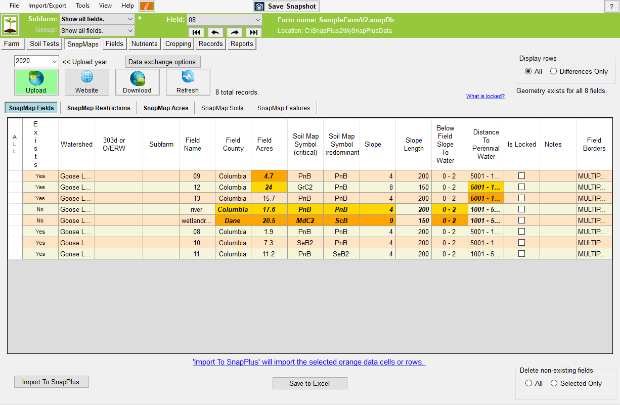
SnapPlus Help Version 19

SnapMaps Tab

SnapMaps Tab

Previous topic Next topic  

SnapMaps Tab

Previous topic Next topic  

The SnapMaps screen manages and imports the data retrieved from the SnapMaps website. The SnapMap Fields tab displays information about each field. The SnapMap Soils tab displays information about the individual soils in each field. The SnapMap Restrictions tab displays information about and imports the restrictions for each field. The SnapMap Features tab displays each point, line and polygon feature created on the website.  The SnapMap Acres tab displays various spreadable acres for each field.


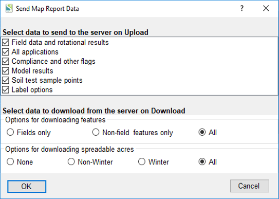
When you first run a new version of SnapPlus, upload your farm data to the website then do a download to get any updates to the mapped features (Soils, SWQMA, nutrient restrictions areas, etc.) . Changes will show up as "differences" (highlighted and bold italics) on the SnapMaps Field, Restrictions or Acres tabs


2019 Snap Map Tab


General Controls

SM_UploadWhite The Upload button sends your farm data to the website. If a field has a polygon it will appear on the map, otherwise its name will appear in the names dropdown. This must be clicked when a farm is created in order to connect the farm with the website. Note: If you have made changes on the website without pressing Download, clicking Upload will wipe those changes out.


SM_WebsiteWhite The Website button opens the SnapMaps website in your default browser. The Upload button must be pressed before the website will work correctly. Note: Microsoft's Internet Explorer browser is not supported. We recommend Microsoft Edge, Google Chrome, or Mozilla Firefox.


SM_DownloadWhite The Download button retrieves the field data  from the website. This will be highlighted in green when changes have been made on the website. Note: This can take a long time if there are a lot of fields.


SM_RefreshWhite The Refresh button highlights/selects the differences between the SnapMaps data and the data in your Fields subtab in the grid. If a cell is different it will be orange when selected instead of blue. To quickly import any new changes, press this button and then the Import To SnapPlus button


SM_ImportButton Imports any selected cells into SnapPlus.


clip0023 Select the Crop Year data you’d like to include when you upload your field data to the web. This data will then be available on the Snap Maps website for display.


clip0068 Select the type of data you would like to send to the server for each upload and download.


KV Send Map Report Data


KV SnapMaps sub-tabs ^^The SnapMap tabs switch between the SnapMaps sub-tabs.


SM_DisplayRows The Display Rows radio buttons switch the grid between displaying all of the fields, or just those which have data which is different than that in SnapPlus.


SM_DeleteNonExisting   The Delete non-existing fields radio buttons delete either all or those of the currently selected fields which do not exist in SnapPlus (meaning they were created on the website and have not been imported).

SM_SaveToExcel Save the grid data to an Excel file.