SnapMap Acres Tab |

|

|
|
SnapMap Acres Tab |
|
|
SnapMap Acres Tab |
|
|
|
SnapMap Acres Tab |
|
|
|
|
||
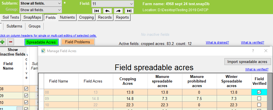
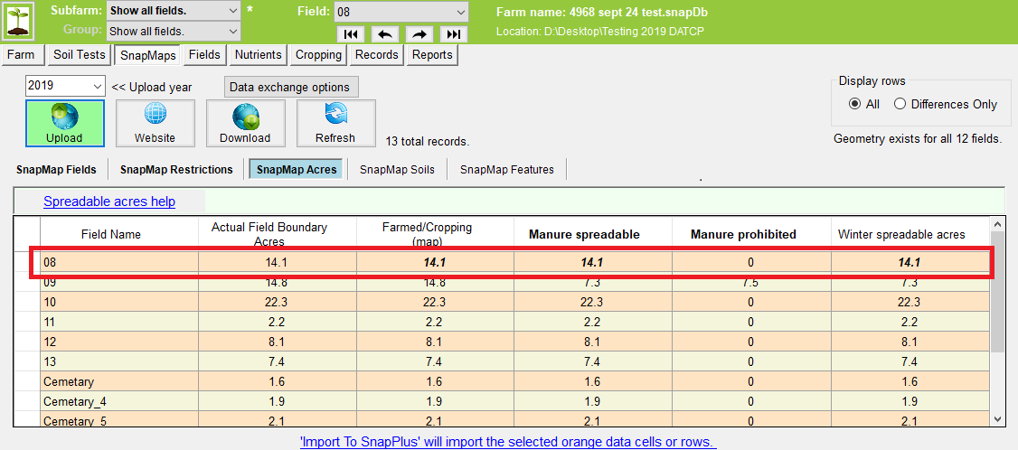
The field spreadable acres are displayed on this tab. The spreadable acres are automatically imported when you import the field data on the SnapMaps Fields tab.
Spreadable acres may be affected when features change on the SnapMaps website for your farm. User made features like wells, sink holes and manure prohibited acres all effect spreadable acres. Base features like Map Symbols, SWQMA, Silurian Dolomite and others may also affect spreadable acres. When you make changes to you farm on the map website always check this tab for changes.
You cannot dismiss individual cells or columns on this tab. Individual rows may be dismissed/activated (toggle the orange cells) with a Ctrl-Click on the row header cells. You may also lock field spreadable acres by going to the field tab and clicking on the Spreadable Acres button to bring up the Manage Field Acres window. Here you can lock field spreadable acres checking the field verified check boxes. Be sure to click on the Save button to save your changes and exit the window.
When you first run a new version of SnapPlus, upload your farm data to the website then do a download to get any changes to the base features (Map Symbols, SWQMA, ...). These changes may also show up as differences on the SnapMaps Field, Restrictions and Acres tabs.
Because the spreadable acres Field Verified box is checked for field 08, the field 08 row in SnapMap Acres is bold Italic indicating a difference but it can not be imported.
Column Meanings
•Field Name: The field name from the fields tab.
•Farmed/Cropping (map):the total acres minus any water and exclusion areas
•Actual Field Boundary Acres: The total acres inside the field boundary.
•Winter Spreadable Acres: Acres that are available to be spread on during the winter months.
If the farm is a CAFO, you’ll see the additional columns related to manure spreading restrictions.
Manure spreadable acres are the cropped acres minus any designated manure prohibited areas from the maps.
Manure prohibited acres are the areas that are cropped but that can't have manure. These include all SWQMA no-manure areas and other manure prohibition areas shown on the maps.
The text, above the grid, reflects the SWQMA Manure Application Spreading Strategies selected for annual and perennial crops on the Farms Screen.
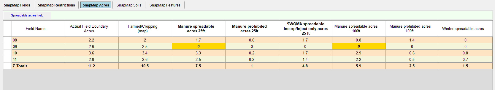
Additional Column Meanings
•Manure spreadable acres 25 ft: Acres that may receive manure outside of the 25 ft buffer around navigable waters, conduits to navigable waters or wetlands in an NR243 (CAFO) SWQMA.
•Manure prohibited acres 25 ft: Acres that may not receive manure within 25 ft of navigable waters, conduits to navigable waters or wetlands in a CAFO SWQMA (SWQMA strategy 1 or 2) .
•SWQMA spreadable incorp/inject only acres 25 ft: Acres within a CAFO SWQMA where manure can be applied if injected or immediately incorporated (SWQMA Strategy 1).
•Manure spreadable acres 100 ft: Acres that may receive manure outside the 100 ft no-manure buffer around navigable waters, conduits to navigable waters or wetlands in a CAFO SWQMA under SWQMA strategy 5.
•Manure prohibited acres 100 ft: Acres that may not receive manure within 100 ft of navigable waters, conduits to navigable waters or wetlands in a CAFO SWQMA under SWQMA strategy 5.
•Winter Spreadable Acres: Acres that are available to be spread on during the winter months.
Note: Spreadable acres are imported even if the corresponding fields have their Verified box checked.