SnapMap Soils Tab |

|

|
|
SnapMap Soils Tab |
|
|
SnapMap Soils Tab |
|
|
|
SnapMap Soils Tab |
|
|
|
|
||
The SnapMap Soils tab displays information about the individual soils which make up each field.
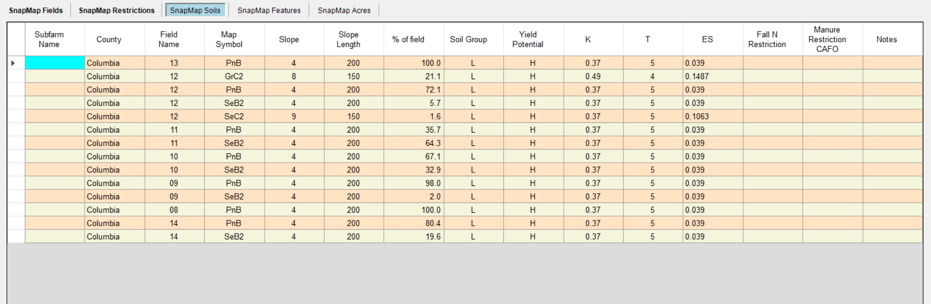
•Subfarm Name: The name of the subfarm the soil's field is in. •County: The county in which the soil is located. This can differ from the field county if the field is drawn across county lines. •Field Name: The name of the field for this soil. •Map Symbol: The symbol representing this soil map unit. •Slope: The typical % slope assigned to this soil map unit in the NRCS database. •Slope Length: The typical slope length in feet assigned to this soil map unit in the NRCS database. •% of field: The percentage of the field covered by this soil. •Soil Group: The soil group for this soil map unit, used for nutrient recommendations. Soils can be Loamy (L), Organic (O), or Sandy (S). The soil properties used to define theses groups are explained in the UWEX publication A2809, page 15. •Yield Potential: A relative ranking of a soils ability to produce high corn yields and the responsiveness of corn yield to nitrogen fertilizer. Yield potential can be High (H), Medium (M), or Sandy (S). The soil properties used to define these groups are explained in the UWEX publication A2809, page 15. •K: The soil erodibility factor. This represents the susceptibility of the soil to detachment and erosion from precipitation and runoff. K factors are used in calculating soil loss. They are based on soil texture, structure, permeability, and organic matter. In Wisconsin they range from 0.02 to 0.55, with higher factors leading to higher calculated erosion rates. •T: The tolerable soil loss in tons per acre per year. This represents the average rate of erosion that occurs without long term degradation of the soil. Tolerable soil loss is assigned by NRCS to each soil with thinner more fragile soils having lower T values. Wisconsin T values range from 1 to 5 tons per acre per year. •ES: The erosion sensitivity. This is used for selecting the dominant critical soil for a field. ES takes into account the water erosion potential of the soil, slope steepness and length, and soil sustainability. It is calculated as ES= K x LS / T, where K is the Soil Erodibility Factor, LS is the combined slope and slope length factored used for calculating soil loss, and T is the tolerable soil loss. The soil map unit with the highest ES value that makes up 10% or more of the area for the field is the dominant critical soil. •Fall N Restriction: Any fall nitrogen spreading restrictions for this soil will shown here. •Manure Restriction CAFO: Any CAFO Manure restrictions for this soil will be shown here. For CAFO farms only. •Notes: Additional information about the soil. This may be filled in by SnapPlus or by you. |