Importing Fields |

|

|
|
Importing Fields |
|
|
Importing Fields |
|
|
|
Importing Fields |
|
|
|
|
||
Field boundaries can be brought into SnapMaps from other programs as Shapefiles.
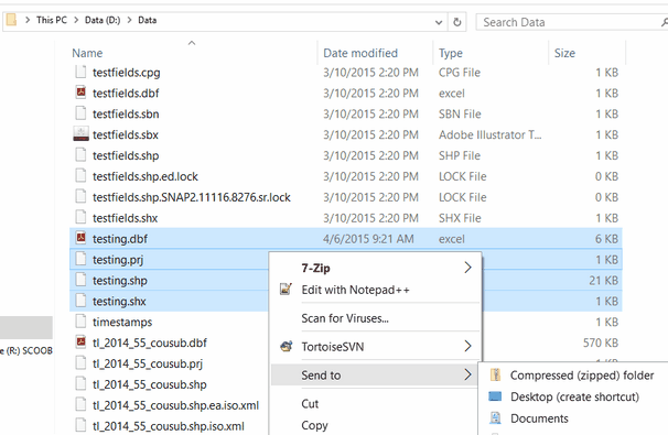
A Shapefile is a file for storing geometry (polygons lines and points) and its associated attribute information (field names, acres, etc.). A shapefile is really a combination of several files with different extensions (an extension is what comes after the dot in the filename), they include .dbf, .shp, .shx, .prj. You may see other extensions such as .sbn or .sbx: these are not required for SnapMaps.
Since a Shapefile consists of several files, we require you to zip up the contents of your shapefile. Some farm software creates a zip file for you when you export your data, others you will need to select them and add them to a zip file. Again the four extensions that you will need for your shapefile are .dbf, .shp, .shx, .prj. If your shapefile comes from SST or FarmWorks, you will not have a .prj file. That’s ok, we have a special import option for you later. Just zip the other three files. Using Windows Explorer find and select the required files. You can do more than one shapefile in a zip file. Then right click your mouse and Send to | Compressed (zipped) folder. This will create your zip file for SnapMaps.
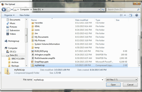
Once you have your zip file containing your shapefiles of your fields, you are now ready to import them into SnapMaps. In SnapMaps select Drawing Tools | Import a Field Shapefile | Select a zip file (Must contain a shapefile). Explore and select the zip file you created previously and click Open.
A new dialog box will appear with some options.
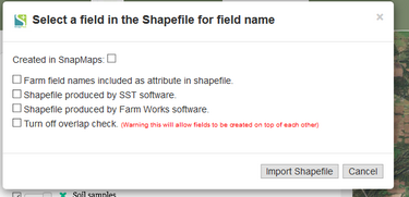
•If the shapefile had been previously created in SnapMaps, just click the Created in SnapMaps checkbox and click Import Shapefile.
•If your field names are part of your shapefile, click Farm field names are included in shape file. This will automatically match up your shapefile fields with the ones you upload from SnapPlus Desktop. This step is optional, but saves you the trouble of editing all the fields in SnapMaps to assign names to the. A drop down box will appear with column names from your shapefile, select the appropriate one. If you don’t have a column within the shapefile that includes names for the fields don’t check this option (in that case, the fields will not be given names, but you can add those later).
•If your field was produced from SST or FarmWorks software, click the corresponding checkbox. This will add the appropriate .prj file that was missing. This will not work with shapefiles that are missing .prj files from software other than SST or FarmWorks. Once you have finished selecting your options click, Import Shapefile. The website will take some time to import the shapefile based on the number of fields it contains. Once it’s done your fields will appear on the map.
•If you want to turn of the overlap check, you can do that by click the Turn off overlap check. Overlap checks for significant overlap of existing fields and if it does find something, it won't import that field.
Please refer to the video tutorial on Importing Shape Files into SnapMaps for more information.