Importing Using Shapefiles |

|

|
|
Importing Using Shapefiles |
|
|
Importing Using Shapefiles |
|
|
|
Importing Using Shapefiles |
|
|
|
|
||
A Shapefile is a file for storing geometry (polygons lines and points) and its associated attribute information (field names, acres, etc.). A shapefile is really a combination of several files with different extensions (an extension is what comes after the dot in the filename), they include .dbf, .shp, .shx, .prj. You may see other extensions such as .sbn or .sbx: these are not required for SnapMaps.
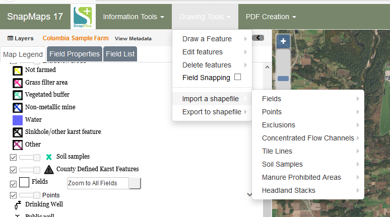
In this chapter we will go over how to import the following Shapefiles:
•Import a Field Shapefile: Use this tool to import fields from a shapefile.
•Import a Point Shapefile: Use this tool to import points from a shapefile.
•Import an Exclusion Shapefile: Use this tool to import exclusion areas from a shapefile.
•Import a Concentrated Flow Channel Shapefile: Use this tool to import concentrated flow channels from a shapefile.
•Import a Tile Line Shapefile: Use this tool to import tile lines from a shapefile.
•Import a Soil Sample Shapefile: Use this tool to import soil samples from a shapefile.
•Import a Manure Prohibited Area Shapefile: Use this tool to import manure prohibited area from a shapefile.
•Import a Headland Stack Shapefile: Use this tool to import headland stack from a shapefile.
Note that the shapefile must be in a zip archive to import. Also features that significantly overlap a feature already in the SnapMaps database for your farm will not be imported from your shapefile into the SnapMaps database.