Contouring and Filter Areas |

|

|
|
Contouring and Filter Areas |
|
|
Contouring and Filter Areas |
|
|
|
Contouring and Filter Areas |
|
|
|
|
||
Contouring
The contouring selections are None, On-contour, and Strip cropping:
•None is the default setting. It should be selected whenever a field is not consistently worked across the slope. For RUSLE2 soil loss calculations, this selection sets the rows to up and down the slope.
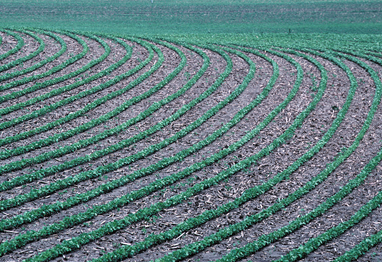
•On-contour should be selected when a field is consistently planted and tilled on the contour across the slope. For RUSLE2 soil loss calculations, this selection sets the row grade as Relative row grade 10% of slope grade. Guidance for contour farming can be found in Wisconsin NRCS Conservation Practice Standard 330 Contour Farming.
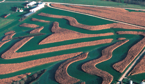
•Strip crop should be selected when contour strips have been installed and maintained on a field. For RUSLE2 soil loss calculations, this selection sets the RUSLE2 strip practice setting to 2-strip rotational 0-2. To use the Strip Cropping option a minimum of 2 contour strips must be placed across the field’s planning slope length identified in SnapPlus. If there are not at least 2 strips across the planning slope length the On-contour option should be selected instead. Guidance for establishing contour strips can be found in Wisconsin NRCS Conservation Practice Standard 585 Strip Cropping.
The filter strip selections are None; Designed, field edge; and Designed, in-field:
•None is the default setting. It should be selected whenever a field does not have a grass filter area within or below it that was designed to capture sediment from that field.
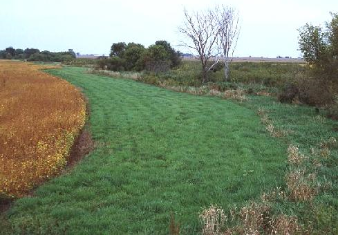
•Designed, field edge should be selected to indicate a grass filter area designed to capture sediment from that field’s runoff.
For RUSLE2 soil loss calculations, a 30-foot cool season grass filter strip (not harvested) is added in RUSLE2 to the lower portion of the field’s designated slope. This new segment has the same % slope as the field. When a Designed, field edge filter strip is chosen, an additional value, Sediment delivery, shows in the Average soil loss space in the Rotation Summary. This is an estimate of the eroded sediment from the field that will be transported in runoff through the filter strip area. Guidance for edge-of-field filter strip planning and design can be found in Wisconsin NRCS Conservation Practice Standard 393 Filter Strip. The main purpose of including edge-of-field grass filter strips as a management option in SnapPlus is to allow planners to estimate approximately how much a properly designed grass filter area at the lower edge of a field would reduce phosphorus and sediment in overland flow from the field.
oWhat can this field-edge filter strip management option do? Show approximately how much a field’s estimated unit area P delivery to surface water (P Index) can be lowered if a grass filter area is established to filter runoff from the field. The sediment delivery, rather than the average soil loss, is used in the P Index for edge-of-field sediment-bound P loss calculations.
oWhat can’t it do? It will not indicate how wide a filter strip needs to be. Properly designed filter strips normally vary in width across the lower edge of a field, taking into consideration field characteristics not in SnapPlus, including site topography, contributing area, and other characteristics like the locations of seeps and wet areas. Also, the sediment delivery shown in SnapPlus represents sediment delivery through the filter area and is not an estimate of sediment delivery to water. Note: The SnapPlus crop acreage and manure and fertilizer application calculations assume the filter strip is constructed below the field itself, if it is constructed within the field, then field acreage should be reduced accordingly in SnapPlus to account for the loss of acreage for crops and applications.
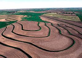
•Designed, in field should be selected to indicate grass buffer strips established on the contour within the field. The infield contour buffer strip must be placed near the mid-point of the field’s planning slope length identified in SnapPlus. If it is not possible to place the contour buffer strip near the mid-point of the planning slope length, the On-contour option should be selected instead. For RUSLE2 soil loss calculations, this selection sets the “Strip barrier systems” to “Contour buffer strips, 1 cool season grass buffer not at end, 15 feet wide”. Guidance for contour buffer strips can be found in Wisconsin NRCS Conservation Practice Standard 332 Contour Buffer Strips. Note: The SnapPlus crop acreage and manure and fertilizer application calculations assume that the acreage entered for a field is all in crops. If you are selecting the “Designed, in field” filter strip option as a “what-if” to determine its effect for conservation planning or nutrient management planning, you will also need to adjust the field acreage in SnapPlus by subtracting the area that will be in grass. To estimate the area in square feet that will be used by the grass buffer strips, take the length of the field (in feet) plus 20% and multiply by the width (in feet) and the number of the grass strips. Hint: One acre = 43,560 square feet.